Sunday, August 28, 2011

Reeder Canyon to Grassy Lake trail loop: bike riding in ATV country

Reeder Canyon: its just on the northwest corner of Joe's Valley Reservoir, tending up-canyon on trail 5 of the Arapeen trail system going west, where it meets with the Southern Skyline Drive portion of the Great Western Trail. I have listed specific milage/elevation and logistical info at the bottom of the post.

Starting the climb is high desert sage and sandstone.

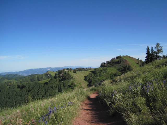
As with most canyons in Utah, a steep, rocky, river-cut V-shaped lower canyon makes for a hard start, till you reach the U-shaped prehistoric hanging glacial valley. Up there, the wildflowers were... well you see the picture....

The wide basin made for a fantastic, meandering climb. Most of it I was able to climb seated, spinning a moderate 32X19 single gear on my 29er.

At the head of the canyon, the alpine meadows make it worth it. The ridge in the background is the highpoint of the loop, standing at 11,000 feet.

After a few hard out-of-the-saddle efforts you reach Skyline drive. While most of Skyline rolls along the high plateau, the junction of with Reeder Canyon occurs at a relative low point of 10,400 feet.

Tempo pedalling out of the basin, passing a sheepherders tent.

The final pitch to the high plateau kicks up a bit. I remember this climb well from when I did the entire 90-mile Skyline drive many years ago. Around the corner of this climb was the site of my geared bike's drive train demise: At the top, a right turn lead to vicious black clay mud, made sticky from 4 inches of snow the night before my years-ago ride. The derailleur of my then-bike snapped. I fashioned a single speed to ride the 30 of the next 60 miles of the route. The final 30 I did with a zero-speed kick bike when that broke. By then I was hooked on single speed and have been ever since. 

At the top. The Skyline drive can be seen rolling along the plateau to the West in the distance, 60 miles to its terminus. 

But I chose to go back east on the Clay Bench canyon rim, where I met this Vaquero in his camper, and his horses---probably a ranch hand for the sheep and cattle that graze here in the Summer months.

The ATV track snaked its way down, hugging the canyon rim on the descent. It had nice bermed corners.

Freaking beautiful. While every mountain biker goes to Moab/Fruita and all that smooth Colorado single track, nobody goes for the infinitely greater milage and remoteness of the Arapeen ATV track of central Utah. The ATV track rides much like single track for all intents and purposes. The gradients are prefect for riding/climbing. And to be honest, you don't see many ATVers except near the trailheads, as most don't ride more than an hour or so before turning back to their campers. Plus, there is a feeling of excitement of exploring undiscovered and remote places that can't be matched. Consider me hooked. There is a lifetime of riding to do in the Southern Wasatch Plateau. I aim to link up as many of these canyons as I can. 

A parting shot of a passing storm over the upper basin of Reeder canyon and the Skyline drive. After parting ways with the canyon rim, I headed down the neighboring Grassy lake drainage (trail 52), till I rode down to the reservoir. 

Stats for those who are interested: round trip was about 30 miles, 8.3 miles out of the canyon, but about 12 miles of climbing total when you include the Clay Bench climb. Bottom to top elevation gain was 2600 feet. A map of the Reeder canyon loop can be found here: http://www.seuohvclub.org/reeder.jpg where my chosen route descended the Clay Bench ridge-line rather than the more common lower descent listed on the map.

The Arapeen OHV trail network summary can be found here: http://sanpete.com/downloads/sanpete_map.pdf

And a more detailed paper map of the entire area can be sent to you for free, or download GPS tracks free, courtesy of Sanpete county, by clicking here: http://sanpete.com/pages/atv_map


Wednesday, August 24, 2011

Single Speeding is Easy

...when you've got the legs...

And right now, I've got them, apparently...
Its also worth noting that single speed is best on shortish rides, with fully recovered legs, like this ride up on the Crest.


From the Crest, to Desolation Lake, to Dog Lake (pictured), and no dogs for some reason...

Sunday, August 14, 2011

Tour of Utah

The breakaway forming on the first lap. Trailer Captain and I found a shady spot on the grass up at Presedent's Circle at the University of Utah, which gave views a small climb and descent around the circle.

The chase. Levi Leipheimer's Radio Shack squad took control of the peloton from the very beginning to control the break.


The descent off the circle was hair-raising, especially the team cars' tire-squealling fun.

Here it is. The pro peloton. In my town. Seeing it in the flesh makes it both amazing and so human: they were averaging 30mph on climbs and descents I know well, which is stupifyingly amazing, but the guys shelled off the back after big pulls at the front reveal the same-old dead tired expression that hangs on anyone's face after a hard ride.

Garmin-Cervelo, Realcyclist, HTC-Highroad, BMC, Gobernacion, Geox, Radio Shack, Spider-tech. Wow. Star power. Even Cadel Evans paid a visit on the next day's queen stage.

Even at the continental pro-level Garmin-Cervelo is a team that seems to have a lot of talent. Three blue helmets in the break...

After 7 or 8 laps, the Radio Shack was shelled. They never closed the break. With all Levi's riders gone but one, he had to lay it on the line in 97-degree heat and drive the pace at the front. It was exciting to watch the man in yellow work for it. He never closed the break, but he closed the time gap enough to protect the lead comfortably. The next day's queen stage (on Sunday) up Little Cottonwood Canyon (Utah's L'Alpe d'Huez) he handily marked the wheel of Gobernacion's Henao, who was the main threat in the breakaway on Saturday.

All told, the addition of the Columbian team Gobernacion was the exciting element to the Tour. With Columbia's heat and high altitude and a group of really strong and lightweight climbers, it made for exciting action.


Saturday, August 13, 2011

The Drama of Puke Hill


A trail route can build a story that is more than a series of challenges in sequence. With any good story, there needs a denouement. Something that makes the challenges coherent: intermediate tests toward and ultimate showdown. 

Puke hill is one of those rides. Now I don't mean riding off the back of your truck from Gaurdsman's. Then Puke Hill is simply a rude awakening. You got to ride from the bottom. Hence Super Crest = Ride from Park City to reach Scott's pass then onto Wasatch Crest trail + Mid-Mountain Trail in one big loop.

So I woke up real early. I must say, that on the way up to ride, I kind of psyched myself out. I have not done any racing this year, so this has become a test of sorts for me.


A smooth ride up to Jupiter bowl.

Keeping it together up to Scott's Pass. 

At the pass, you round the bend, the angle kicks up. Then it starts. Every undulation you got to keep in check. As you ascend the pitch keeps increasing. Then riding is a process of extrapolation: If you are 30% from readline, then you can count down to meltdown with every pitch increase.


Triumph at the top---counted down before meltdown.

All cruiser from here...

The crest in its crestyest...

20 more miles of this...


Sunday, August 7, 2011

Consider the Pony Ride


Consider the pony ride. Just consider it, because like Trailer Captain, you may not be ready to saddle up yet...


Or consider a wild goose chase. Who's up for one?

Or consider a World Dog at the Wheeler Farm Farmers' Market on Sunday. This is one of the many fine food carts that can be found in our fair city of Salt Lake, normally found around Highland and the Patagonia outlet, but Sundays at Wheeler.

Consider the look of a true champion. One that rises to the occasion and gives their all, in this case, for a salsa competition---I have a feeling she practices the her look-of-a-champion at home, alone, in the mirror. Do you? As in, do you also practice too? You should. Their salsa was pretty good.

Consider the other fine pleasures of Summer, like a tractor barrel ride.

The look of a champion.

Apropos wild goose chases, our happening upon the Wheeler Market was a random act, starting with a morning TTC ride on the Jordan River Parkway.

Champion of one-handed-tandem-riding-photography...

The Continental Squad, picnicking somewhere along the river in Murray...


Saturday, August 6, 2011

Consider the Indian Paintbrush---Wasatch Lake Hopping

Steady as she goes...

Catherine pass meadow overlooking Alta basin.

It was a good meadow...

At the pass: the enduring landmark of my western life.


On the third day in a row of hiking, we hopped to an unknown lake near Guardsmen's. Rock throwing and splashing ensued.

As did some relaxing...

The Indian Paintbrush (Castilleja). This is probably the first flower I ever remember learning about. I distinctly remember my Mom pointing these out to me while hiking above timberline on Mount Hood in Oregon. They live in western mountainous and arid regions. I've since learned that the flowers are edible and sweet---don't eat the green parts though, high in alkali. The Chippewa first nation uses the leaves as a condiment with other greens in a salad as well as treatment for rheumatism. They are also a parasitic plant, whose roots tap into other plants nearby to get water and nutrients.